Property Record
2975 Shawnee Ridge Ct, Suwanee, GA 30024
NEARBY LISTINGS FOR SALE OR LEASE
Property Detail
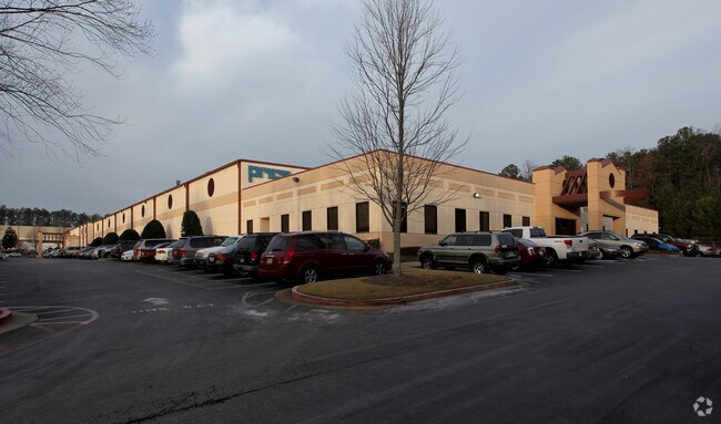
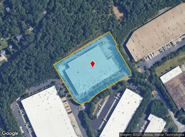
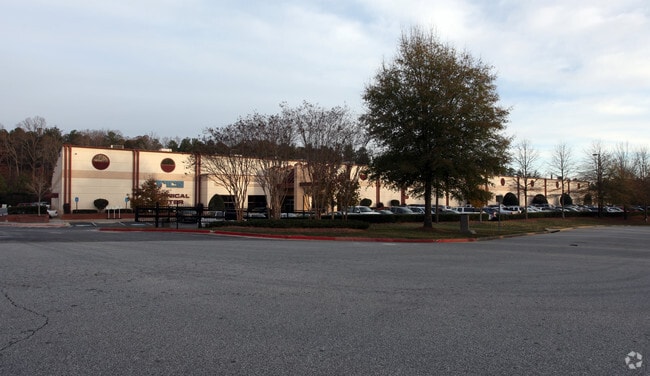
2975 Shawnee Ridge Ct
7-154-023
Shawnee Ridge
Warehouse
SHAWNEE RIDGE COURT
X
Gwinnett
13135C0043F
Georgia
2025
8.34 AC
2025
Duluth/Suwanee/Buford
050232
Atlanta
156,910 SF
Atlanta-Sandy Springs-Roswell, GA
DEMOGRAPHICS near 2975 Shawnee Ridge Ct
1 mile
3 mile
5 mile
2024 Total Population
3,638
67,380
195,394
2029 Population
3,801
70,655
204,604
Pop Growth 2024-2029
+ 4.48%
+ 4.86%
+ 4.71%
Average Age
40
39
38
2024 Total Households
1,214
23,704
67,753
HH Growth 2024-2029
+ 4.53%
+ 4.97%
+ 4.86%
Median Household Inc
$95,598
$94,329
$88,413
Avg Household Size
3.00
2.80
2.80
2024 Avg HH Vehicles
2.00
2.00
2.00
Median Home Value
$426,344
$364,400
$349,422
Median Year Built
2000
1997
1997
Nearby Places
Map Layers
Map Styles
 Street
 Aerial
Transit
 Traffic
 Biking
Places
Listings with unknown addresses are not visible on the map
- Restaurants
- Banks
- Shops
- Fitness
- Groceries
PUBLIC TRANSPORTATION
AIRPORT
Hartsfield - Jackson Atlanta International
Drive
Walk
Distance
Hartsfield - Jackson Atlanta International
52 min
38.6 mi
Nearby Properties
Address
Land Use
TOTAL SIZE
Lot Size
Zoning
Address
Land Use
TOTAL SIZE
Lot Size
Zoning
1,457,980 SF
98.78 AC
MUR
Address
Land Use
TOTAL SIZE
Lot Size
Zoning
482,658 SF
17.05 AC
MUR
Address
Land Use
TOTAL SIZE
Lot Size
Zoning
1,588,972 SF
112.95 AC
C2
Address
Land Use
TOTAL SIZE
Lot Size
Zoning
509,302 SF
55.13 AC
RM8
Address
Land Use
TOTAL SIZE
Lot Size
Zoning
684,224 SF
77.07 AC
OI
Address
Land Use
TOTAL SIZE
Lot Size
Zoning
534,578 SF
44.21 AC
RM8
Address
Land Use
TOTAL SIZE
Lot Size
Zoning
365,821 SF
17.08 AC
RM24
Address
Land Use
TOTAL SIZE
Lot Size
Zoning
393,939 SF
42.21 AC
RM8
Address
Land Use
TOTAL SIZE
Lot Size
Zoning
404,176 SF
32.67 AC
M2
Address
Land Use
TOTAL SIZE
Lot Size
Zoning
393,913 SF
25.93 AC
RM13
Address
Land Use
TOTAL SIZE
Lot Size
Zoning
280,454 SF
19.97 AC
MUR
Address
Land Use
TOTAL SIZE
Lot Size
Zoning
359,241 SF
21.02 AC
PMUD
Address
Land Use
TOTAL SIZE
Lot Size
Zoning
471,807 SF
69.50 AC
R100
Address
Land Use
TOTAL SIZE
Lot Size
Zoning
379,183 SF
6.09 AC
PMUD
Address
Land Use
TOTAL SIZE
Lot Size
Zoning
285,038 SF
1.93 AC
MUR
Address
Land Use
TOTAL SIZE
Lot Size
Zoning
340,573 SF
22.12 AC
RM13
Address
Land Use
TOTAL SIZE
Lot Size
Zoning
334,841 SF
28.14 AC
RM13
Address
Land Use
TOTAL SIZE
Lot Size
Zoning
304,276 SF
14.90 AC
MUR
Address
Land Use
TOTAL SIZE
Lot Size
Zoning
439,723 SF
64.56 AC
R100
Address
Land Use
TOTAL SIZE
Lot Size
Zoning
428,329 SF
18.44 AC
RM24
Address
Land Use
TOTAL SIZE
Lot Size
Zoning
372,904 SF
11.64 AC
PUD
Address
Land Use
TOTAL SIZE
Lot Size
Zoning
253,169 SF
8.74 AC
RM24
Address
Land Use
TOTAL SIZE
Lot Size
Zoning
377,960 SF
29.70 AC
RM13
Address
Land Use
TOTAL SIZE
Lot Size
Zoning
365,351 SF
30.70 AC
OI
Address
Land Use
TOTAL SIZE
Lot Size
Zoning
234,420 SF
10.35 AC
PMUD
Address
Land Use
TOTAL SIZE
Lot Size
Zoning
373,242 SF
6.41 AC
RM24
Address
Land Use
TOTAL SIZE
Lot Size
Zoning
220,779 SF
7.32 AC
PMUD
Address
Land Use
TOTAL SIZE
Lot Size
Zoning
287,187 SF
9.96 AC
RM24
Address
Land Use
TOTAL SIZE
Lot Size
Zoning
248,400 SF
13.92 AC
MUO
Address
Land Use
TOTAL SIZE
Lot Size
Zoning
282,713 SF
25.95 AC
RM13
The World's #1 Commercial Real Estate Marketplace
Connect with us
© 2026 CoStar Group
The information above has been obtained from sources believed reliable. While we do not doubt its accuracy we have not verified it and make no guarantee, warranty or representation about it. It is your responsibility to independently confirm its accuracy and completeness. Any projections, opinions, assumptions, or estimates used are for example only and do not represent the current or future performance of the property. The value of this transaction to you depends on tax and other factors which should be evaluated by your tax, financial, and legal advisors. You and your advisors should conduct a careful, independent investigation of the property to determine to your satisfaction the suitability of the property for your needs.